Preprocessing Verification & PCA-based NDSI
Prior to analysis, the quality of preprocessed input datasets was verified to ensure spatial consistency, radiometric integrity, and freedom from significant cloud or speckle contamination. Sentinel-2 QA60-based cloud masking effectively removed the majority of cloud and cloud shadow pixels. Sentinel-1 SAR preprocessing produced VV and VH backscatter composites free from systematic geometric distortions, with values in the accumulation-season composites ranging from approximately −15 to −5 dB in VV polarization, consistent with expectations for snow-covered alpine terrain at C-band frequencies. Co-registration between Sentinel-1 and Sentinel-2 composites was achieved at sub-pixel accuracy, and z-score normalization confirmed that all nine input bands contributed approximately equally to the PCA.
Accumulation-Season NDSI
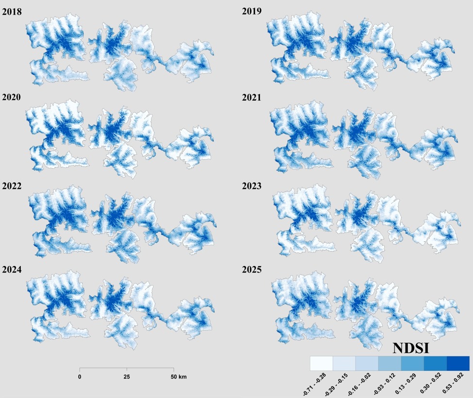
The seasonal mean NDSI maps for the accumulation period reveal a clear and consistent altitudinal gradient in snow cover intensity across Hohe Tauern National Park over 2018–2025. High-elevation areas (> 2000 m a.s.l.) consistently exhibit NDSI values approaching the upper bound of the index (≥ 0.90), indicating persistent and optically dense snow cover throughout all years. Lower-elevation zones (< 1500 m) display markedly lower NDSI values, reflecting partial or ephemeral snow cover subject to recurrent melt events. Over 2018–2022, accumulation-season NDSI values at mid-to-high elevations increased progressively, reaching peak values of approximately 0.99 by 2022. In contrast, the later years (2024–2025) exhibit a measurable shift: NDSI values in valley and foothill zones decline substantially, with minimum values reaching approximately −0.55 to −0.66 in the lowest elevation zones.
Depletion-Season NDSI
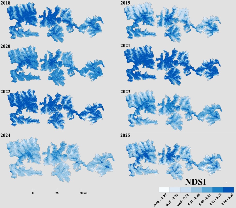
Depletion-season NDSI maps show a comparable altitudinal structure, with high-elevation zones maintaining NDSI values between 0.90 and 0.96 throughout the study period, reflecting persistent residual snowpack in spring, while valley floors display NDSI values indicative of snow-free or largely snow-depleted conditions. A modest reduction in peak high-elevation NDSI is observed during 2021–2022 (~0.91). A partial recovery is evident in 2023 (~0.95). These patterns indicate that while the upper alpine zone sustains relatively consistent depletion-season snowpack, mid- and lower-elevation zones experience progressive loss of spring snow cover, consistent with a warming-driven upward shift of the seasonal snowline.
Accumulation ↔ Depletion — NDSI Comparison
Drag the slider to reveal how the same landscape transforms between the peak accumulation season (winter) and the depletion season (late summer), sensor-derived NDSI year by year across 2018–2025.
Snow Cover Classification — Accumulation Season
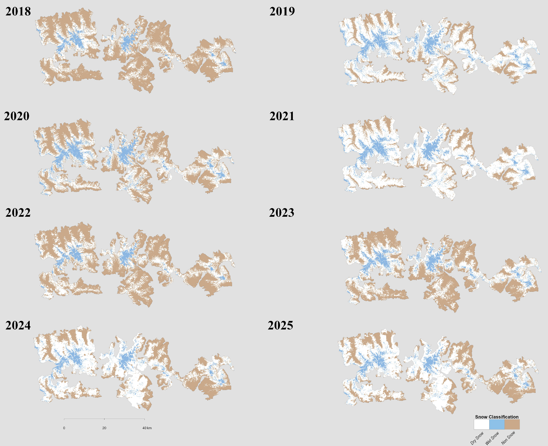
The rule-based classification of accumulation-season composites reveals pronounced temporal and elevation-dependent variability. In Zone I (< 1500 m), Non-Snow area increases progressively, peaking at approximately 42.49 km² in 2023. In Zone II (1500–2000 m), Non-Snow area reaches its maximum extent of approximately 153.01 km² in 2023. In Zone III (2000–3000 m), Wet Snow consistently dominates despite a slight declining trend. At the highest elevations (Zone IV, > 3000 m), Dry Snow area shows a substantial reduction after 2020 while Wet Snow remains relatively constant (~80.48 km² in 2020 to 79.37 km² in 2025). This shift from Dry to Wet Snow at the highest elevations indicates that warming is penetrating even the most elevated portions of the park.
Snow Cover Classification — Depletion Season
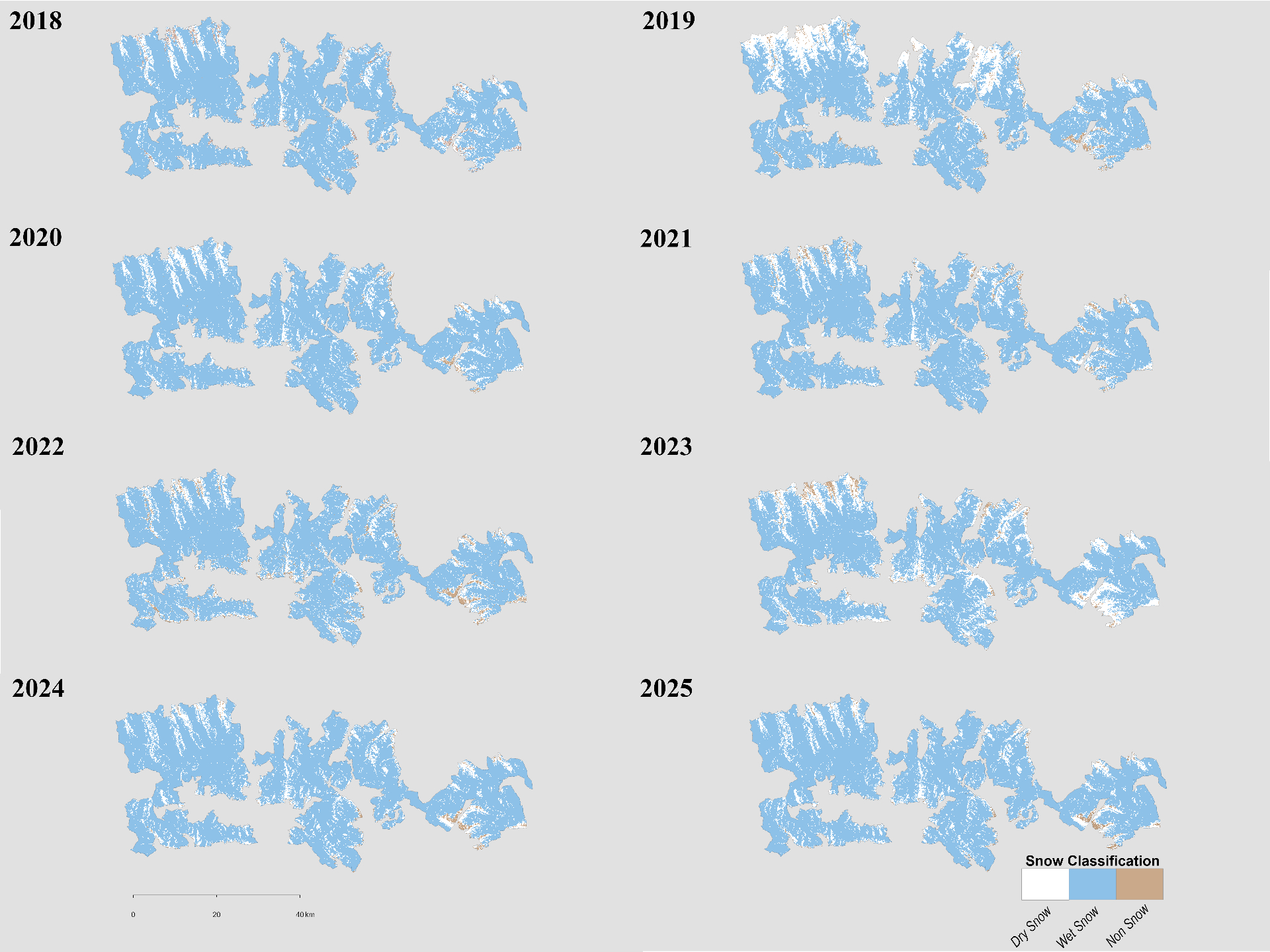
The depletion-season classification documents a progressive transition over 2018–2025. In the early phase (2018–2019), Dry Snow was largely confined to elevations above 2500 m, while Non-Snow dominated valley floors. During 2020–2021, Wet Snow expanded substantially in mid-elevation zones. By 2022–2025, Non-Snow areas had expanded significantly across Zones I and II, while Dry Snow retreated to isolated high-elevation patches (> 3000 m). A spatially consistent aspect dependency was identified: north-facing slopes (315°–360° and 0°–45°) retained proportionally greater Dry Snow coverage compared to south-facing slopes (135°–225°). In Zone III, Dry Snow declined sharply in 2024 to approximately 1.36 km², its lowest value within the depletion-season record.
Accumulation ↔ Depletion — Snow Classification
Compare how Non-Snow, Dry Snow, and Wet Snow classes redistribute between the two seasons. Drag the handle to sweep between them.
Inter-annual Snow Cover Change
During the accumulation season, net snow cover change was predominantly negative at elevations below 2000 m across most annual transitions, with the largest losses occurring between 2022–2023 in Zones I and II. Snow expansion events were detected primarily above 2500 m in the 2020–2021 and 2021–2022 pairs. During the depletion season, the change maps reveal a consistent pattern of snow area reduction at lower elevations across all annual pairs, with the rate of retreat intensifying in the latter half of the study period (2022–2025). Persistent snow areas were concentrated above 2500 m in all pairs, confirming the stability of high-elevation snowpack.
Accuracy Assessment (AUC–ROC)
The AUC–ROC analysis evaluated the discriminatory capability of NDSI products derived from Sentinel-2 (10 m), Landsat 8/9 OLI (30 m), and MODIS (500 m). Sentinel-2 achieved the highest AUC value of 0.98, indicating excellent discrimination ability. Landsat-based NDSI achieved an AUC of 0.8321, demonstrating strong discriminatory capability. The MODIS NDSI product yielded an AUC of 0.7028. Overall, all three sensors demonstrated operationally useful discriminatory capability (AUC > 0.70). Sentinel-2 exhibited the highest discrimination ability, making it particularly suitable for detailed snow-cover assessments in heterogeneous alpine terrain such as Hohe Tauern National Park.